Biking and Hiking New Zealand - 18 Kepler Track to Gunns Camp
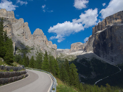
Two months since leaving Munich. Looking through this little notebook, I can already feel a certain distance from the beginning of the trip. That was not yesterday anymore, but already quite a while ago. From Brod Bay to Luxmore Hut I was feeling strong and moved quickly: two and a quarter hours instead of the official 5–6 hours. Some people do it even faster. Apparently there was someone at Luxmore trying to do the entire Kepler Track in a single day and chase a new record. Then on along the ridge for about three hours, and the descent to Iris Burn really did take only two more. I arrived there at 13:15. Tomorrow the distance is similar, but with hardly any elevation gain, so it should also be manageable before 3 p.m. If that works, I can catch the first shuttle back to Te Anau.


Kepler Track
The Kepler Track is a 60-kilometre circular walking track near Te Anau in Fiordland National Park and is one of New Zealand’s Great Walks. It was created in 1988 both as a centennial project and to help ease pressure on the more famous Milford and Routeburn Tracks. Named after the nearby Kepler Mountains, which in turn honour the astronomer Johannes Kepler, the route links a remarkable range of landscapes in a relatively compact circuit: lake shore, beech forest, alpine ridges, tussock country, wetlands, deep gorges, and river valleys. Set between Lake Te Anau and Lake Manapouri, it gives walkers a broad introduction to Fiordland without requiring the long transport logistics of some of the region’s other tracks.
Compared with many New Zealand backcountry routes, the Kepler Track is built to a very high standard. Streams are mostly bridged, boggy areas are protected by boardwalks, and the steepest climbs are assisted by long stair sections. For that reason it is often considered one of the more accessible Great Walks, even though it still involves substantial effort and changing mountain weather. Most walkers take three or four days, usually beginning at the Lake Te Anau control gates and heading first to Luxmore Hut, then over the exposed ridge and down to Iris Burn. It can also be shortened by using access points such as Rainbow Reach, though the full circuit is the classic way to experience it.
The Kepler is also unusual among Great Walks in being a purpose-built track rather than one that simply evolved from an old Māori trail or early settler route, though parts of the area had been explored and used earlier, including for grazing. Its modern history is tied to the efforts of Fiordland National Park Board members Alf Excell and Les Henderson, who imagined an “Around the Mountain Walk” linking existing and newly built sections into a complete loop. The result is a track that has become not only a major tramping route but also the setting for the annual Kepler Challenge, a mountain running race in which elite runners complete the 60 kilometres in under five hours. That contrast — from three- or four-day tramp to world-class racecourse — says a great deal about the Kepler’s excellent design and enduring appeal.


| Place | Day (Full) | Day (Short) | Distance | Time | Description |
|---|---|---|---|---|---|
|
Lake Te Anau Control Gates 45°26′30.5″S 167°41′23″E |
1 | 5.6 km (3.5 mi) | 1.5 hours | The track follows the shores of Lake Te Anau through beech forest to sandy Brod Bay, where camping is permitted and where it is possible to enter or leave the track by arranged shuttle boat. | |
| Brod Bay | 1 | 8.2 km (5.1 mi) | 3.5–4.5 hours | From Brod Bay, the track climbs past limestone bluffs (747 m / 2,451 ft) to Luxmore Hut (1,085 m / 3,560 ft) on Mt Luxmore. A short side walk from the hut leads to a cave, one of about 30 in the area, many of them still unexplored. | |
| Luxmore Hut | 2 | 2 | 14.6 km (9.1 mi) | 5–6 hours |
A gradual climb leads to Luxmore Saddle (1,400 m / 4,600 ft), the highest point on the main trail,
with extensive views of the park. There is also an opportunity to climb Mt Luxmore
(1,472 m / 4,829 ft) for a 360-degree view including Lake Te Anau.
Emergency shelters are located at Forrest Burn and Hanging Valley, though overnight stays are forbidden except in an emergency. The trail then follows a long open ridge toward Iris Burn and descends by zigzags into a hanging valley. It continues through forest, passes a large natural landslide, and reaches Iris Burn Hut (497 m / 1,631 ft), which stands in a large tussock clearing about 1.5 km from Iris Burn Falls. |
| Iris Burn Hut | 3 | 3 | 16.2 km (10.1 mi) | 5–6 hours | The track climbs over a low saddle and wanders through mixed forest to the large slip created during heavy rain in January 1984. It then sidles through a gorge, comes out onto river flats near the mouth of the Iris Burn, and follows the lakeshore around Shallow Bay to Moturau Hut, beside a beach with views of Lake Manapouri. |
|
Moturau Hut 45°28′54″S 167°36′37″E |
4 | 6 km (3.7 mi) | 1.5–2 hours | This short section crosses many small streams before running beside the Waiau River to the Rainbow Reach swing bridge, where there is a car park and tramper bus services. | |
|
Rainbow Reach Swing Bridge 45°29′27″S 167°39′45″E |
9.5 km (5.9 mi) | 2.5–3.5 hours | The undulating track traverses mixed forest and crosses many small streams before arriving back at the Lake Te Anau Control Gates. | ||
| Lake Te Anau Control Gates | End of the circuit. |


Set off at 7:15, arrived at 13:00. The weather became nice too, lovely until 18:00, then clouds again. 22.2 km and hardly any elevation gain. Yesterday evening I met two Austrians who are also travelling by bike, apparently for five months, and still very young. Te Anau, then Milford Road. In the evening, grilling at the campsite.


Te Anau
Te Anau is the main settlement on the eastern shore of Lake Te Anau in Southland and one of the key gateways to Fiordland. Though still a small town, it occupies a strategically important position between Invercargill, Queenstown, Milford Sound, and Manapouri, and for many travellers it is the last substantial base before entering the wilder landscapes of the southwest. The name is often interpreted from Māori as “the place of the swirling waters,” and the town’s setting beside New Zealand’s second-largest lake gives it an immediate scenic presence, with the Kepler and Murchison ranges rising beyond the water.
Te Anau developed relatively late compared with other New Zealand towns. Europeans first reached the lake in the 1850s with Māori guides, but the settlement itself only began to take shape in the 1890s, not long after the Milford Track opened. Real growth came much later, especially after the Homer Tunnel opened in 1953 and made road travel to Milford Sound possible. Since then Te Anau has become the main service centre for Fiordland tourism, combining accommodation, transport, supplies, and visitor infrastructure with a still fairly relaxed small-town atmosphere.
Today Te Anau is above all a base for outdoor travel. It is closely linked to some of New Zealand’s best-known walks, including the Kepler and Milford Tracks, and it also serves visitors heading to Doubtful Sound, the Te Ana-au glowworm caves, and the many shorter walks, cycle trails, and lookouts around Lake Te Anau. Tourism and farming dominate the local economy, and in summer the town’s accommodation capacity expands far beyond its permanent population. For trampers, cyclists, and anyone heading into Fiordland, Te Anau is less a destination in itself than the practical and scenic threshold to one of the wildest parts of the country.


I did not leave the campsite until 9:00. Breakfast in Te Anau, and I bought five tins of tuna for pasta. I had seen the Austrians do that — better than tomato sauce.
Heading north from Te Anau direction Milford Sound and after The Divide a turn into Hollyford Valley and to Gunns Camp, which began 1938 as a Public Works Department camp built for the men working on the Hollyford-Okuru Road. No phone, no Internet, hot water for showers heated by wood fire (that is 2015 not 1938 I am talking about).
The ride through the Eglinton Downs began in good weather, but by the time I reached Gunn’s Camp it was raining, and the gravel road soaked me properly. At the camp itself the rain had stopped again, though the sky remained heavily overcast. I definitely want to stay at least three nights here. Five would also be possible. Quite a strong headwind from the north today.


Fiordland National Park
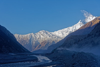
Fiordland National Park occupies the far southwest corner of New Zealand’s South Island and is the largest of the country’s national parks, covering more than 12,600 square kilometres. It forms a major part of the Te Wāhipounamu World Heritage Area and protects one of the most dramatic landscapes in New Zealand: glacier-carved fiords, steep mountain ranges, deep valleys, remote lakes, waterfalls, and vast temperate rainforests. The park’s scenery is dominated by the southern reaches of the Southern Alps, with famous places such as Milford Sound / Piopiotahi, Doubtful Sound / Patea, and the great lakes Te Anau and Manapouri helping define the image of Fiordland as one of the wildest corners of the country.
Fiordland also has a long human history, though permanent settlement was always sparse because of the terrain and weather. Māori knew the region for centuries, using its coast and waterways as seasonal routes for travel, fishing, birding, and the gathering of resources such as pounamu. In Māori tradition, the fiords were carved by Tū Te Rakiwhanoa to make the land habitable. European knowledge expanded in the late 18th century with Captain Cook’s visits, and later explorers, surveyors, and trampers gradually made Fiordland better known. By the early 20th century, much of the region had already been recognised as too spectacular and too special to exploit fully, leading to large areas being set aside for protection and eventually formal incorporation into the national park system.
Ecologically, Fiordland is one of New Zealand’s greatest refuges for native life. Its forests, wetlands, offshore islands, and alpine environments support many rare and threatened species, including takahē, mōhua, kākāpō, tokoeka, Fiordland crested penguins, bats, and reptiles. The region’s huge rainfall — among the highest in the world in some places — feeds dense mossy forests of beech, podocarps, ferns, and liverworts, though introduced deer, possums, stoats, and rats have long posed major threats. Conservation work in Fiordland has been nationally important, from Richard Henry’s early bird translocations in Dusky Sound to modern island sanctuaries, takahē recovery, and predator control. The region has repeatedly stood at the centre of New Zealand conservation history, most famously in the Save Manapouri campaign of the 1960s and 1970s.
For visitors, Fiordland is one of New Zealand’s greatest destinations, though access is concentrated in only a few corridors. Most people experience the park via the Milford Road from Te Anau, or through Manapouri on trips to Doubtful Sound. It is also one of the country’s most celebrated tramping regions, containing or bordering famous tracks such as the Milford, Kepler, Routeburn, and Hollyford. Yet beyond those well-known routes lies a much larger and harsher wilderness of remote valleys, difficult river crossings, deep mud, sandflies, and weather that can change suddenly and trap walkers for days. That contrast between accessibility at the margins and true wilderness beyond them is part of what makes Fiordland National Park so compelling: it is both a world-famous destination and one of the last places in New Zealand that still feels genuinely immense and untamed.


Gunn’s Camp
Gunn’s Camp, in the Hollyford Valley near the southern end of the Hollyford Track, began not as a tourist stop but as a Public Works settlement in the 1930s. The small timber cottages were built to house road workers and their families during attempts to push road access farther into this remote part of Fiordland. That road-building effort was never fully completed, and the little settlement later drifted into a second life. Some buildings survived more or less intact, while others were stripped for useful materials in later years, but the overall layout still preserves the feel of an isolated workers’ camp set beneath steep mountains and close to the river.
The place later became closely associated with David “Davey” Gunn (1887–1955), the bushman, cattle farmer, guide, and legendary figure of the Hollyford Valley from whom the camp takes its name. Gunn came from a Scottish farming family, worked first in agriculture elsewhere in the South Island, and in 1926 bought freehold land in the Hollyford. He expanded his holdings in 1929 and moved into the valley, establishing himself at Deadman’s Hut on the banks of the Hollyford River. There he ran cattle in rough country, cut tracks, built huts, and became known for his energy, bushcraft, and deep knowledge of the valley. In 1936 he also came to wider public attention after making an extraordinary 21-hour journey through difficult country to help survivors of an aircraft crash at Big Bay.
That same year Gunn began guiding parties along what became known as the Hollyford Track, and he continued doing so until his death in 1955. By all accounts he was a hospitable and memorable guide, and his name became inseparable from the valley. On Christmas Day 1955 he drowned while fording the Hollyford River on horseback near Hidden Falls, an end as dramatic and unforgiving as the country he knew so well. His son Murray Gunn later carried on in the area, developing Gunn’s Camp into a rest stop for trampers, with accommodation, a store, and a small museum. Through that transition, the site shifted from road-workers’ housing to something more unusual: a rustic base for walkers that still retained the rough improvisational spirit of old Fiordland.
Historically, then, Gunn’s Camp is important for two overlapping reasons. First, it is a rare surviving reminder of interwar attempts to open up Fiordland by road. Second, it is tied to one of the best-known personalities in the history of the Hollyford Valley. That double identity explains why the place feels so distinctive. It is not simply “old accommodation,” but a fragment of New Zealand backcountry history still in use: part workers’ settlement, part trampers’ outpost, part memorial to a vanished era of guides, bushmen, and isolated valley runs.
For someone staying there several nights and taking many photographs, Gunn’s Camp offers far more than convenience. The appeal lies in its scale and atmosphere: small cottages, shared facilities, wood smoke, old jokes and signs, and buildings that seem to sit lightly in the landscape rather than dominate it. Even now it gives a strong impression of what travel in remote Fiordland must once have felt like — a little shelter, warmth, and company in a place where the mountains, river, weather, and darkness remain the real masters of the scene. That mixture of history, eccentricity, and setting is what makes Gunn’s Camp memorable well beyond the usual campsite or hostel stop.