Biking and Hiking New Zealand - 07 Lake Waikaremoana
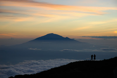
First day of my little holiday within the holiday. Sunshine, very warm weather, but most of the time in the forest for four hours. It was my first really nice hike of the trip. Tomorrow I may even swim in the lake. There were about 12 people in the hut, which has room for 36 — a mixed group of older and younger people, tourists and Kiwis. A couple from Christchurch gave me their number. In the evening I made a fire, though it was not easy with the damp wood. The huts are very basic: no blankets, no cooking equipment, and of course no food. You have to carry everything you need for four days and take all your rubbish out again. There are campsites too, and in high season they may be worth considering if the snoring of up to 40 people in one room sounds unappealing. There is plenty of fish in the lake if you want to improve your meals — or, at least in theory, you could go hunting deer.


Lake Waikaremoana
Lake Waikaremoana lies deep within Te Urewera and is one of the most remote and atmospheric lakes in the North Island. Its name means “sea of rippling waters,” and despite being a lake it often feels larger, wilder, and more sea-like than the name first suggests. Formed by a giant landslide dam, it is the deepest lake in the North Island and is surrounded by forested slopes that have remained much less modified than most of the country.
Part of what makes Waikaremoana special is its isolation. The long unsealed access road keeps visitor numbers lower than on many of New Zealand’s other Great Walks, and that gives the place a quieter, more self-contained feel. The track follows forested ridges, lake inlets, and long stretches of shoreline, with huts and campsites spaced along the way.


The Legend of Haumapuhia
According to Māori tradition, Lake Waikaremoana is linked to the story of Haumapuhia. She was the daughter of a chief and, after angering her father, was transformed into a taniwha. In her struggle to escape, she carved through the landscape, trying to reach the sea. One of her attempts formed an inlet of the lake, and when she finally emerged near the Waikaretaheke River, the rising sun turned her to stone. Like many Māori place traditions, the story explains landscape through memory, ancestry, and transformation. Around Waikaremoana, the lake is not only a natural feature but also a place shaped by story.


Up at 5:45. Cereal and tea for breakfast. Only two and a half hours to the next hut, which had 18 beds. I stayed there, made some tea, and then walked to a set of waterfalls, about one and a half hours each way. Back at the hut by 13:30. A bigger group seemed to be arriving in the evening. Their luggage had already been brought in by boat, and three people had already lit a fire in the afternoon. I also had a short swim in the lake — refreshing, but very cold. This is no sea, of course, just a very cold lake.


Te Urewera
Te Urewera is one of the most distinctive landscapes in New Zealand: mountainous, forested, remote, and historically closely associated with Tūhoe. For a long time it was managed as Te Urewera National Park, but since 2014 it has held a unique legal status and is no longer a national park in the conventional sense. Instead, Te Urewera is recognised in law as its own entity and is governed through an arrangement involving both Tūhoe and the New Zealand state. That status reflects not only ecological value but also history. Te Urewera remained difficult for outsiders to control because of its isolation and dense forest, and it has long stood for a different relationship between land, people, and authority. Walking around Lake Waikaremoana, you feel that remoteness very clearly.


I did not meet a single person between 6:30 a.m. and 2:00 p.m. Yesterday’s larger group turned out to be the senior management team of a food company from Gisborne. They did not drink any alcohol, but still snored like champions. I was in a different room with four women, and in the evening some people I knew from the Mokau campsite turned up. A lot of ups and downs along the lake today. After three days of walking through forest, I am already looking forward to getting back on the bike. But I still want to do Abel Tasman National Park later, maybe for two or three days. That will be quite different from this. Another quick swim in the lake, about 14°C. Tomorrow at 2 p.m. the water taxi is supposed to pick us up. There had been a landslide near the end of the track, and the bridge there was closed.


Last day of the walk. Rain on the way back. The water taxi crossing was quite bumpy because of the strong wind. We were given coffee and a blanket, and it was pretty cold out on the lake. Later at camp there was hail, snow, and rain, but a hot shower, lots of tea, chips, and pasta with sauce lifted the mood again.
Lake Waikaremoana Great Walk
The Lake Waikaremoana Great Walk is a 44-kilometer hiking trail that traces the southern and western shores of Lake Waikaremoana in New Zealand's North Island. The track meanders through diverse forests and grasslands, frequently offering scenic views of the lake. Recognized as one of New Zealand's Great Walks, it is situated in what was once Te Urewera National Park.
The trail begins at Onepoto and Hopuruahine, located on the southern and northern ends of the lake, respectively. Hikers typically spend 3 to 4 days completing the route.
The path traverses several sections of private land and skirts the Puketukutuku Peninsula Kiwi Refuge.
| Place | Distance | Time | Description |
|---|---|---|---|
| Onepoto | 8.8 km | 5 hours | Passing the former Armed Constabulary Redoubt near the start of the trail, the track then climbs steeply up onto Panekire Bluff. The bluffs form part of the southern shore, and provide views over the expanse of the lake. Following the ridge, the trail has several sharp dips and climbs. Panekire Hut sits in a small clearing next to the Panekire Trig point (1180 m), at the top of the cliffline, with views of the lake. |
| Panekire Hut | |||
| 7.6 km | 3–4 hours | The trail from Panekire Hut goes west, climbing and descending over the Panekire Range, before eventually descending precipitously into much taller and wetter forest. At the end of the descent lies Waiopaoa Hut and Campsite, on the edge of the Waiopaoa Inlet part of the lake. | |
| Waiopaoa Hut and Campsite | |||
| 3.6 km | 1.5 hours | Passes grassland, and forest, usually 10–20 m from the lakeshore. Just before Korokoro campsite, there is a turnoff up Korokoro river, to Korokoro Falls which takes about 30 minutes each way. | |
| Korokoro Campsite | |||
| 6.8 km | 2.5 hours | This section has a very large number of meanders in the trail, as it follows the lakeside, and toward the Maraunui Campsite, follows a river upstream, before crossing it, and returning downstream. | |
| Maraunui Campsite | |||
| 1.7 km | 0.5 hours | A brief walk through grassland and over a small ridge. | |
| Marauiti Hut and Campsite | |||
| 6.2 km | 2 hours | Apart from a brief climb over a small peninsula, the trail follows the shoreline as it meanders northeast. | |
| Waiharuru Hut and Campsite | |||
| 2.1 km | 1.5 hours | Climbing fairly steeply, the trail crosses the neck of the Puketukutuku Peninsula, touching the edge of the Kiwi Reserve area. Descending the other side of the peninsula, the trail arrives at the Tapuaenui Campsite, back on the lake shore. | |
| Tapuaenui Campsite | |||
| 3.2 km | 1 hour | Again following the shore, the trail meanders along, through forest, before arriving at Whanganui Hut. | |
| Whanganui Hut | |||
| 2.7 km | 0.75 hours | After a short walk through the forest, the trail arrives at the beach where water taxis pick up and set down passengers (they use the rocks on the east end of the beach). Sandflies are a problem whilst waiting here. | |
| Water Taxi Stop | |||
| 1.25 hours | |||
| Hopuruahine |