Cycling Annapurna Circuit - Overview
The Annapurna Circuit is a trekking route around the Annapurna mountain range in the Nepalese Himalayas. It can be completed in 14 to 21 days by acclimatized and conditionally prepared trekkers. Most of the route passes through the Annapurna Conservation Area Project (ACAP), Nepal's first and largest protected landscape area.
Most trekkers start from Besisahar (780 m). The route passes through the villages of Khudi (820m), Tal (1620m), Pisang (3180m) and Manang (3530m) to the Thorong La pass (5416m). Via the holy pilgrimage place Muktinath (3790m), the district capital Jomsom (2770m) and Marpha (2680m) you finally reach Tatopani (1160m), which is famous for its hot springs. A last ascent over the Ghorepani Deorali ("Horse watering pass") at 2874 m and Poon Hill (3210 m) leads to Birethanti, from where taxis or buses start to Pokhara.
The trek leads most of the time - with the exception of the immediate surroundings of Thorong La - through agriculturally used, populated land. Refreshment and sleeping facilities are available everywhere, so that the trek is logistically no problem.
Since 2008 there has been an off-road and motorbike track from Pokhara via Tatopani and Marpha to Jomsom and on to Ranipauwa and Muktinath.
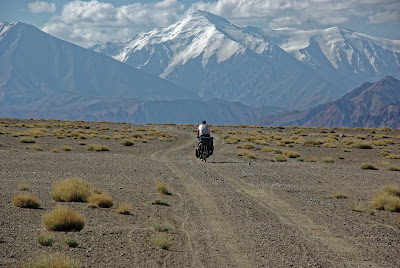
On the other side of Thorong La a road from Besi Sahar to Manang was completed and opened in 2015.With a few exceptions, it is possible to ride the Annapurna Circuit by mountain bike in about 14 days. The terrain changes between asphalt and gravel roads up to single trails. You find suggestions for your itinerary online, one example
- Day 01 - From Kathmandu, travel west to Besisahar [820m] via private vehicle or public bus, taking six to seven hours.
- Day 02 - Trek to Khudi [790m]
- Day 03 - Trek to Bahundanda [1310m]
- Day 04 - Trek to Jagat [1290m]
- Day 05 - Trek to Dharapani [1920m]
- Day 06 - Trek to Chame [2630m]
- Day 07 - Trek to Upper/Lower Pisang [3190m]
- Day 08 - Trek to Manang [3520m]
- Day 09 - Rest day in Manang [3520m]
- Day 10 - Trek to Yak Kharka [4000m]
- Day 11 - Trek to Thorung Phedi [4500m]
- Day 12 - Trek to Muktinath [3800m], crossing the Thorung La en route
- Day 13 - Trek to Marpha [2665m]
- Day 14 - Trek to Lete [2470m]
- Day 15 - Trek to Tatopani [1160m]
- Day 16 - Trek to Ghorepani [2775m]
- Day 17 - Trek to Birethanti [1050m] and travel to Pokhara
My itinerary
I travelled from Munich via Istanbul to Kathmandu with Turkish Airlines, my own bicycle in a card box for 80Euros extra. Arrival in Kathmandu at about 1 p.m. (2 hours late). I booked a room at Kathmandu Eco Hotel and they offered me to collect me at the airport, bicycle traveled on the roof, no problem. Nice welcome in that hotel quite central in Thamel with tea and a good talk what to do the next day(s). What I had to do: collect a TIMS (Trekkers’ Information Management Systems) card at the Tourist Service Center, Bhrikutimandap, Kathmandu (open from 10 am to 5 pm, 7 days a week) and an ANCAP or Annapurna Conservation Area Entry Permit at the same place. The hotel arranged a short taxi drive to the bus station in the north and at 6.30 a.m. I sat in a mini bus from Kathmandu to Besisahar where I arrived at about 2 p.m.
For the trip around Annapurna I created three pages (with pictures)
From Pokhara to Kathmandu I used a "Tourist Bus" called Greenline Tours, that was a convenient choice, because my hotel in Pokhara was just 300m away from their bus stop in the morning. I stored my card box for the bicycle in the cellars of the hotel in Kathmandu, and stayed another 2 nights in Kathmandu Eco Hotel before it was time for my flight back to Munich (Turkish Airways again)